Besuchte National Parks
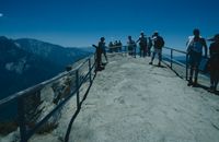
Yosemite National Park
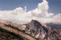
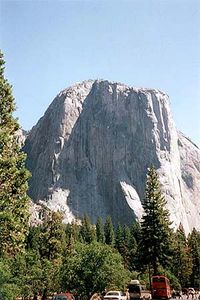
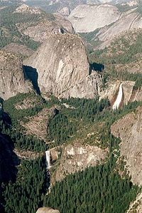
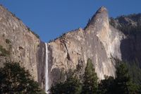
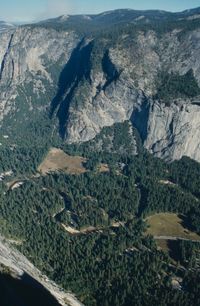
Das Zentrum des Yosemite Tales ist durch einen Gletscher in der letzten Eiszeit entstanden, der die wunderschönen und atemberaubenden Gegend entstehen lies. Ein bekannter Felsen ist der "Half Dome", Die Spitze ist ca. 3000 Fuss hoch. Im gesamten Park sind Wasserfälle; es befinden sich auch der 3. und 7. hoechste Wasserfall der Welt in dieser Gegend. Gegründet wurde der Park 1880 und erfreut sich wachsender Beliebtheit. Im Zentrum befindet sich ein Campingplatz mit vielen feststehenden Zelten, wo übernachtet werden kann. Ein Einbett-Zelt kostet ca. 48$ pro Nacht. Da in dieser Gegend noch Bären leben muss das Essen und andere Süssigkeiten in verriegelten Metallkasten untergebracht werden. Wer noch mehr über den Park erfahren will, kann unter denn angegebenen Links zu verschiedenen Homepages sich weiter informieren.
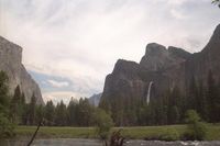
It covers a huge area of the western Sierra Nevada mountains in central California and has innumerable lakes, meadows, forests and rocky summits with endless unspoilt Alpine scenery. At the center is Yosemite Valley, a half-mile deep depression carved by glaciers during the last ice age, which now has soaring 3000 foot high granite domes and many powerful waterfalls, including the third and seventh highest in the world. The area received National Park status in 1880, as a result of the efforts of the pioneering Scottish naturalist John Muir, and has grown in popularity ever since. Two roads lead up Yosemite Valley for 20 miles and form part of an extensive one-way system; the North side Drive westwards and the Southside Drive eastwards. They pass through flat woodland and flower-filled meadows with occasional named viewpoints, past picnic spots and short trails leading to and along the Merced River. Development is concentrated along the last 3 miles of the roads - many car parks, RV sites, campgrounds, shops, hotels and other buildings. Most accommodation needs to be booked many months in advance, but for campers at least, there are other, better options in several official sites in the forests outside the valley, along the approach roads.
Sequoia National Park
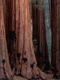
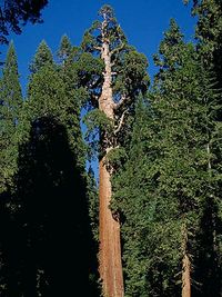
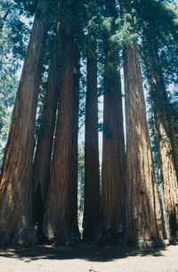
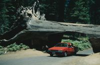
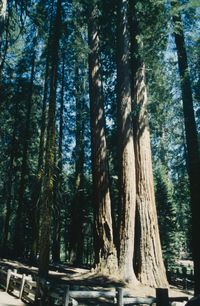
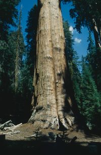
Der Sequoia National Park ist wohl wegen der Welt größten Bäume einer der bekanntesten Parks in ganz USA. Der Park liegt südlich von Yosemite National Park und von Los Angeles benötigt man ca. 4 Stunden fahrzeit mit dem Auto. Die obere rechte Karte zeigt das gesamte Gebiet rund um den Park. Die Mammutbäume wachsen nur auf einer Höhe von 5000 - 7000 Fuss und in dem Sequioa Park ist auch das größte Lebewesen: der Sherman Tree. Der Baum ist 83,8m hoch und sein Stamm-Umfang am Boden umfasst 31,3m. Es gibt zwar noch höhere Mammutbäume (bis zu 106,7m) aber in Masse kann dem Sherman Tree keiner das Wasser reichen. Er hat ein Volumen von 1486,6m3 und ist damit der als das grösste Lebewesen auf Erden. Im Park können verschiedene Wanderungen zu den Mammutbäumen gemacht werden, auch sind die dicksten unten ihnen mit Namen versehen, so gibt es einen Präsidenten, the Senate Group, House Group, Mc Kinley und den General Lee Tree. Im südlicheren teil des Seqoiua National Parks befindet sich ein Tal mit einer Kupfer Mine und dem höchsten Berg der USA: Mount Whitney. Die Weg zu Mineral King führt auf eine Höhe von 2286m und es können mehere Wanderungen, zum teil zu kleinen Gletscher-Seen unternommen werden. Zu empfehlen ist es, in den Sommermonaten immer ausreichend Wasser mit dabei zu haben und sich an das Höhenklima zu gewöhnen. Eine sehr schöne Wanderung ist der Weg zu Monarch Lake. Es sind bis dorthin 6,7 km und ist einer der leichteren Wanderungen. Von dem See aus kann dann noch zu einem Pass weitergewandert werden (Sawtooth pass) und die Höhendifferenz ist 366m. Das letzte Teilstück zum Pass ist alles Sandstein, was bedeutet es geht zwei Schritte vorwärts und einen zurück. Auch sollte man wegen des losen Gesteins stets vorsichtig agieren. Angelangt am Pass ist einem der wunderschoenste Ausblicke auf die suedliche Sierra sicher. Der Pass ist auf einer Höhe von ca. 3500m. Es lohnt sich wirklich die Mühe auf sich zu nehmen und die gesamte Wanderung bis zum Pass und zurück zum Auto kann bei einer guten Kondition in einer Tagestour geschafft werden
Big trees are the prime attraction of Sequoia National Park - many groves of the remarkable giant sequoia are found scattered along the moist, west-facing slopes of the Sierra Nevada mountains, between elevations of 5000 and 7000 feet. The scale and grandeur of these reddish giants is quite stunning, and there are many easy foot trails that wind through the woody groves leading to quiet undisturbed places, ideal to contemplate the ambience of the forest. Sequoia is the second-oldest national park in the United States. It was established in 1890 to protect the Big Trees in Giant Forest, including the General Sherman Tree, the world's largest living thing. Sequoia also contains the Mineral King Valley and Mt. Whitney, the highest mountain in the U.S. outside of Alaska. Sequoia also contains the Mineral King Valley and a rare expanse of undisturbed Sierra foothills. Mt. Whitney, the highest mountain in the U.S. outside of Alaska, towers along the eastern boundary.
Mineral King Valley, an open glacial canyon hemmed in by the peaks of the Great Western Divide, has a special place in the hearts of many park visitors. Accessible only by a long, slow going road, the valley is a place where nature, not man, dominates. The elevation at the floor of the Mineral King Valley is 7500' (2286 meters). Hiking at this altitude is strenuous. Gauge your hiking to the least fit member of your party. During the early summer, mosquitoes can be a particular nuisance. As in all areas of the park, it is best to carry water, as the purity of the lakes and streams along the trails cannot be guaranteed. Upper and Lower Monarch Lakes lie at the foot of Sawtooth Peak, at the end of a 4.2 mile (one-way) hike. This is one of the easier hikes in the Mineral King area, but since the trail follows a west-facing slope, it is best to get an early start. The trail passes through meadows, red fir forest, and the avalanche-scoured Chihuahua Bowl, a basin named by hopeful miners for an area of rich mines in Mexico. It then rounds a shoulder and gives views north and east across the Monarch Creek canyon to
Timber Gap, the Great Western Divide and Sawtooth Pass. Beyond the lakes, the trail climbs 1200' in 1.3 miles (366 meters in 2 km) to Sawtooth Pass, a strenuous hike, but one that provides one of the grandest views in the southern Sierras. The footing on this portion of the trail is very loose. Please use caution.
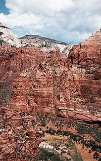
Zion National Park
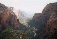
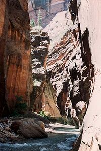
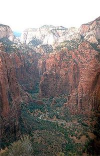
Einer der ältesten National Parks ist der Zion National Park mit seinen unglaublich faszinierenden Felsen. Ein 6 Mile langer Weg fuehrt hinein in das Herzstück des Parks. Schluchten und steile Felsen geprägt von einer unglaublich grossen Anzahl an verschiedenen Farben lassen einem die Natur hautnah erspüren. Entstanden ist die Schlucht vor Millionen von Jahren durch den Fluss Virgin River, der nach wie vor durch das Tal fliesst. Mit dem Auto kann bis zur engsten der Schlucht in 20 Minuten gefahren werden. Auf dem Weg dorthin gibt es mehrere Wanderwege und auch für professionelle Bergsteiger bieten die steilen und zum teil mehrere hundert Meter hohen Felshänge ein breites Übungsfeld. Angekommen am Ende der Autostrecke kann noch zu fuss weiter in die Tiefe der Schlucht hineingegangen werden und besonders der Sonnenaufgang wie Sonnenuntergang lassen ein bizarres Farbenspiel an den Sandsteinfelsen entstehen. Die meisten Wanderwege sind soweit ausgebaut, dass auch behinderte mit Rollstuhlen sie benutzen können. Im Canyon selber sind die Wege recht einfach, ausser es wird der Weg zu einem Gipfel gewählt. Zeitlich ist man zwischen 1 und 2 Stunden pro Wanderung unterwegs und es lohnt sich mehrere zu machen. Auf dem Weg nach Brcye Canyon aber noch innerhalb des Zion National Parks kann man auf einen Aussichtspunkt gelangen. Der Weg dorthin führt entlang einer Schlucht und es kann einen sehr schönen Aussichtspunkt erreicht werden.
One of the nation's oldest national parks, Zion has a quiet grandeur that is unique. The 6-mile drive into the heart of verdant Zion Canyon brings visitors past such scenic wonders as The Great White Throne, The Watchman, Grotto Picnic Area, Angels Landing, Weeping Rock, the trail to Emerald Pools and the fantastic Gateway To The Narrows Trail, which is suitable for strollers and wheelchairs with assistance. After millions of years, the Virgin River continues to flow through the masterpiece it has created. There are several easy, self-guiding trails in Zion National Park, along with more strenuous hikes. Sure-footed hikers enjoy hiking in the Virgin River itself (a wet hike most enjoyable in the warm months) through the Zion Narrows. Here you can experience the power of millions of years of erosion as you make your way through slot canyons. These canyons are hundreds of feet high, and at times, only an arm's stretch across. While this provides for an exciting hike, it can also be very dangerous. The Virgin River is the natural drainage for a large geographic area. A downpour rainstorm, completely out of sight from within the Narrows, could fill these narrow canyons in seconds! Such flash floods have been known to strand or kill hikers. Therefore, such hikes require advanced check in at the ranger station.
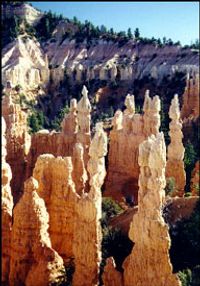
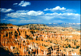
Bryce Canyon
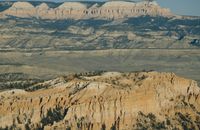
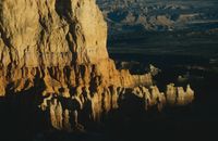
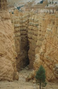
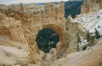
Bryce Canyon ist ein Canyon ohne gleichen. Gleich der erste Eindruck vom Inspiration Point aus ist so umwerfend und faszinierend, dass man gar nicht mehr weggehen möchte. Wie im Laufe der Jahrtausende die Erosion solch farbenprächtige und einzigartige Formen entstehen lies ist einfach unglaublich. Man blickt auf das Meer spitzartiger Felsen ( "hoodoos") und wundert sich nur, dass die Felsen so stabil sind und nicht allesamt zusammenfallen. Der Bryce Canyon befindet sich auf einer Höhe von ca. 7000 bis 9000 Fuss, was im Winter dann auch heisst, dass Schnee liegt, aber das macht es nur noch umso bizarrer. Jedes Jahr besuchen über 1.5 millionen Touristen den Canyon und sie kommen aus der ganzen Welt. Sprachen sind dort genauso vielfältig wie die Formen und Farben der "hoodoos", was die Begeisterung zum Ausdruck bringt. Geöffnet ist der Park das ganze Jahr öber und bietet Erholungsmöglichkeiten für jede Saison an. Wanderungen, Besichtigungen und fotografieren sind die populärsten Sommeraktivitäten. Im Frühling und im Herbst sind weniger Touristen anzufinden und es kann die Einsamkeit erlebt werden. In den Wintermonaten ist die Einsamkeit combiniert mit der besten Luftqualität, so kann über 200 Milen weit gesehen werden. In allen vier Jahreszeiten jedoch sagen die fantastischen Felsgesteine uns was hier im Bryce Canyon geschätzt werden soll.
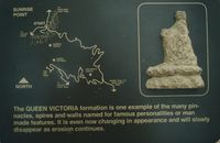
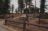
Entlang des Canyons fährt eine Strasse, die im Rainbow Point endet. Auf dem Weg dorthin können immer wieder Aussichtspunkte (Sunset Point, Sunrise Point, Inspiration Point, Bryce Point, Natural Bridge Point, Farview Point) und Startpunkte für Wanderungen angefahren werden. Wanderungen sind dringend zu empfehlen, um die bizarren Gebilde aus der Nähe zu betrachten und zu bestaunen. Wie es in Amerika üblich ist, werden besondere Sehenswürdigkeiten, wie Steinformationen mit Namen versehen. So gibt es einen Queens Garden und eine Wall Street. Queens Garden deswegen, weil eine Felsspitze herausragt und von mehreren kleineren umgeben wird. Auch gibt es eine Queen Victoria. Die "Wall Street" ist nach New York benannt und es kommt einem so vor, als ob man zwischen riesigen Wolkenkratzern durchgeht. Es ist einfach unbeschreiblich.
Erosion has shaped colorful limestones, sandstones and mudstones into thousands of spires, fins, pinnacles and mazes. Collectively called "hoodoos," these unique formations are whimsically arranged and tinted. From sunrise to sunset, the changing scene passes before you in vivid color. The reds and yellows are caused by iron oxides in the rocks: the purples and lavenders by manganese. Dazzling light plays upon the rock to immerse you in an vivid light show.
Bryce Canyon National Park is named for one of a series of horseshoe-shaped amphitheaters carved from the eastern edge of the Paunsaugunt Plateau in southern Utah. Ponderosa pines, high elevation meadows and fir-spruce forests border the rim of the plateau, while panoramic views of three states spread beyond the park's boundaries. This area boasts some of the nation's best air quality. This, coupled with the lack of nearby large light sources, creates unparalleled opportunities for star gazing.
It is tempting to tell you what you will see here, but that is impossible. Day will break or night will fall; the light will shift and it will all be different. A thunderstorm will rearrange sediments, pushing them one step seaward. Or you will find yourself standing in a slightly different place and even that is enough to change your outlook. And your outlook counts. The Paiute Indians' name for Bryce Canyon was simply a description which translates: "Red rocks standing like men in a bowl-shaped canyon." It would be hard to gauge the Paiutes' attitude toward this place from such a straightforward description if we knew nothing else about them. But we know that they attach spiritual values to Bryce Canyon, just as many visitors feel geological time and its vastness
better in Bryce Canyon than anywhere else.


Joshua Tree National Park
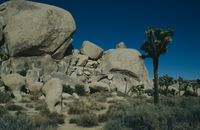
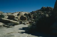
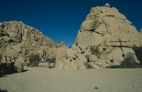
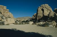
Die Wüste im Joshua Tree National Park ist eine wunderschönes aber auch schwaches Gleichgewicht zwischen den dort lebenden Pflanzen, der Wildnis und den Felsen. Der Park schliesst eine der interessantesten geologischen Offenbarungen ein, die jemals in der Californischen Wüste gefunden worden sind. Der Joshua National Park spaltet sich in eine Hochebene (3000 - 5000 Fuss) und eine niedrigere Ebene (1000 - 3000 Fuss). Auch in diesem Park sind Wanderungen möglich und anzuraten, um die Natur kennenzulernen und zu erleben. Felsen wie sie im ersten der vier Bilder gezeigt werden sind wie von Geisterhand zu "kleinen" haufen zusammengekommen.
The desert at Joshua Tree National Park is a beautiful and fragile balance of plants and wildlife and rocks. The park encompasses some of the most interesting geologic displays found in California's deserts. Rugged mountains of twisted rock and exposed granite monoliths testify to the tremendous earth forces that shaped and formed this land. Arroyos, playas, alluvial fans, bajadas, pediments, desert varnish, granites, aplite, and gneiss interact to form a giant desert mosaic of immense beauty and complexity. Rock climbers come from all over the planet to take on Joshua's geology; the park has 5,000 charted climbing routes.
Two deserts, two large ecosystems primarily determined by elevation, come together at Joshua Tree National Park. Few areas more vividly illustrate the contrast between high and low desert. Below 910 meters (3000 feet), the Colorado Desert, occupying the eastern half of the park, is dominated by the abundant creosote bush. Adding interest to this arid land are small stands of spidery ocotillo and jumping cholla cactus. The higher, slightly cooler, and wetter Mojave Desert is the special habitat of the undisciplined Joshua tree, extensive stands of which occur throughout the western half of the park.
Standing like an island in a desolate sea, the oases, a third ecosystem, provide dramatic contrast to their arid surroundings. Five fan palm oases dot the park, indicating those few areas where water occurs naturally at or near the surface, meeting the special life requirements of these stately trees. Oases once serving earlier desert visitors now abound in wildlife.